Water Routes Worksheet
Trace the flow of water from springs to the ocean
The water routes worksheet helps students trace the flow of precipation from springs,
brooks, creeks, rivers, and into the ocean.
Free Download Below

MatchCard Science Water Routes Worksheet
Objective: Trace the route water follows to get to the ocean.Vocabulary: Spring, Stream, Brook, Creek, River, Estuary, Ocean, Waterway, Watershed
Download and Use the Water Routes MatchCard
This is MatchCard #4 of the Oceanography Unit Study. More information on the MatchCard Science curriculum is at the bottom of this page.Getting Ready: Discuss Your Local Water Routes
Start by asking your students where the rain water that falls into your yard goes. See if the students can trace the flow of water to the nearest brook or creek.What river would your creek join? From there, can you follow the route from river to river until it gets to the ocean?
Watershed
Now is a good time to introduce the concept of watershed. A watershed is an area of land that drains its water into a single body of water such as a stream or lake.The boundaries of a watershed are hills, ridges, and other natural geologic structures on the surface of the earth.
Most likely, your neighbor's waterfall is in the same watershed. But if there is a ridge between your land, it might not be.
Imagine you lived on a large piece of land with a hill in the middle (or maybe you do.) If the rain on one side flowed in one direction, and the rain on the other flowed in a different direction, there are two different watersheds.
Another name for watershed is drainage basin. Compare the two terms. Which do you think is more accurate?
Project: Look for images of watersheds on the internet. Can you find which watershed you live in? Some watersheds have local organizations that ask for volunteers to help measure the depth of the brooks and creeks at specific intervals. Would you like to help study and track local watersheds?
Follow the Water Routes Worksheet
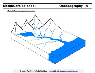
Let's look at the water routes worksheet as we follow the path of rain water from mountain springs to the ocean.Springs
Springs occur when underground water comes to the surface. Often the springs are in the mountains, as water seeps below the mountain rocks and comes to the surface.The water from springs is often bottled because it does not have the chemicals that may be found in streams due to factories and farms.
Streams of streams
A stream is a relatively narrow body of water that has a current flowing in one direction. A stream can be a brook, creek, or river.Brook
A brook is a very small stream. It is made of water that runs off of surface of the land or from springs. Brooks are shallow, narrow, and can easily be crossed on foot.
Creek
A creek is a small to medium sized stream. It contains the water that has drained from brooks, springs, and land.
Creeks are usually only navigable by recreational boats since they are often too shallow or rocky for larger water craft.
River
A river is a medium to large stream. It is made of the water that has drained from brooks, creeks, and smaller rivers. The bodies of water that flow into a river are its tributaries.
The definitions of brook, creek, and rivers may change in different parts of the world. Also, a stream may be called by a name it was given many years ago even if it is not accurate. For instance, pioneers may have named a stream "Fox River" even though it is only a creek, and it continues to be called by that name.
Estuary
The estuary is where the fresh water from the river and the salty water from the ocean mix. You can see it on the water routes worksheet as the larger mouth of the river.What causes the two kinds of water to mix? Answer: Current of the river flowing towards the ocean, and the waves of the ocean moving towards the land.
Ocean
Oceans are the largest bodies of water. They cover 3/4 of the Earth's surface. The water in the ocean is salty.Compare salt and fresh water fish. Use a grocery circular to find the kinds of fish available to eat in your area. Divide a poster in halves with fresh water fish on one side and salt water fish on the other. Add pictures or names of fish according to the place they live.
The Big Picture
Waterways
Waterways are bodies of water that are navigable for transportation or commerce. Waterways include rivers, large lakes, and oceans.Compare watershed and water routes
Compare the diagram on the water routes worksheet and the diagrams students found on the internet or watersheds. Describe how they are similar and how they are different.Answer: They have a similar branching picture. The water routes cover a much larger area.
To some extent, we could almost say that a large body of land or continent is like a super-watershed. The branching pattern could also be compared to root systems, the circulatory system, or paths to roads to highways.
Field Trip
Let's hit the trail to gain more experience with our local waterways. You can walk or bike to follow your water route from your yard through to the drainage point of your local watershed. At different points, you may want to measure the depth and take photos.Unless you are more dedicated than most, you might want to continue your journey following the water route by car. Check a map. Some streams may have roads that travel along side them for several miles, others may not. Step at frequent intervals and compare the depth, rate of current, and width.
If possible, trace the water route from a brook to creek to river. If you live far inland, it may not be possible to trace it much further in a one day's field trip. But at least follow it by map. Don't forget a picnic basket for a lunch by the riverside.
MatchCard Science
How To Use MatchCards

Download the FREE MatchCard Science Instructor's Guide and see how MatchCards can make building their science knowledge base fun.
Ocean Unit Study
12 Science Unit Studies

Chemistry is only one of twelve complete unit studies for kids in 3rd to 8th grade.
Comprehensive objectives, hands-on projects, suggested science fair experiments, and the fun game-like MatchCards keep them interested in learning science. See all twelve MatchCard Science Unit Studies.
About Our Site
Hands-On Learning
